
Data Analysis Findings
NDWI (Normalized Difference Water Index) of Inis Oirr’s Terrain (Sept ’22 – Dec ’23)
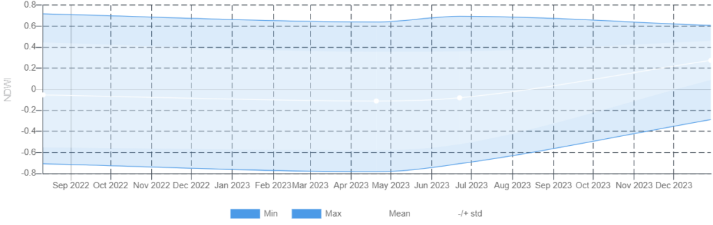
What Does This Represent?
The NDWI graph displayed here represents the fluctuating water content in the vegetation and soil of Inis Oírr over the course of September 2022 to December 2023. The data trend remains relatively low for most of the period, indicating drier conditions, typical of the island’s natural climate cycle. However, there’s a notable increase in moisture towards the end of 2023. This rise might correspond to increased rainfall or could suggest changes in local agricultural practices, such as irrigation. These observations are crucial for effective land management, helping to ensure that the island’s farming techniques continue to harmonize with the natural ecosystem.
NDVI (Normalized Difference Vegetation Index) of Inis Oirr’s Terrain (Sept ’22 – Dec ’23)
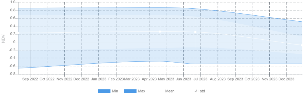
What Does This Represent?
The NDVI graph we’ve compiled for Inis Oírr spans from September 2022 through December 2023, providing a clear visual representation of the island’s vegetative health over time. Beginning at a stable NDVI value of 0.2, indicative of moderate vegetation activity, we observe a slight fluctuation within the 0.2 to 0.3 range throughout the year. This stability points to a consistent vegetative cover, suggesting that the plants and crops are thriving under the prevailing conditions. However, as we move into the latter part of 2023, there’s a noticeable shift. The values taper off to 0.2 in August, further decline to 0.1 by October, and interestingly, dip just below zero in December. This gradual decrease highlights the seasonal transition of vegetation towards dormancy, underlining the effects of changing environmental factors such as temperature and daylight hours on plant life. This graph not only showcases the natural decline and flow of vegetation life but also serves as an invaluable tool for local agricultural planning, ensuring that farming practices are aligned with the seasonal cycles of the island.
Relevance to This Project?
By examining NDVI and NDWI data, we uncover the essential relationship between vegetation vigor and moisture levels on Inis Oírr, aligning perfectly with this project’s aim: “Utilising Copernicus Sentinel Satellite Data to analyse the changing patterns of agriculture on Inis Oírr.” This analysis is key to understanding the environmental dynamics that shape agricultural practices on the island.